This is a l-o-o-o-n-g post with many photos, so get a drink and snack and put your feet up and settle in for the ride (ho ho ho).
At the end of my previous travel post “Apogee” I had travelled south from the gemfields to Injune and was staying at the racecourse.
I stayed a second night and was up before dawn to catch the sunrise. Looking east across the racecourse the view was spectacular with landscape details in silhouette against the bright dawn.

From the same spot looking west the moon looked down on the row of vans (mine in the middle, still hooked up).

Behind the caravans the faint pink colour of dawn slowly moved down the sky, crowding out the darker nighttime azure.

More apparent over the adjacent farmland. It was quite cool - around 4ºC and dry.

I wandered back and cooked some water (I’m learning new skills each day!) and warmed my freezing fingers around a cuppa, then packed up, lowered the roof, checked the tow hitch and tail lights, and started south again. I drove to Roma, filled the fluids (diesel, coffee) and set off again. An uneventful drive to Surat.
Surat has a large flat area set aside for caravans and campers, on the north bank of the Balonne River just over the bridge from the township, a ten minute walk.
Amenities (toilets, showers, waste dump) are provided by a fishing club with help from the local council and gold coin donations, and are very well maintained. There were around 30 vans and motorhomes at the site.

I parked and set up and decided to wander into town for a life-giving flat white and some greasy lunch. Across the bridge

Apparently the river rises above the bridge about once a decade.
Some evidence of the past, slowly falling into disuse.


There was a fairly prosperous looking pub and opposite was the “Wagon Wheel” store and café, apparently named to associate with the adjacent historical Cobb and Co Changing Station (link to some good photos at Tripadvisor)
In I went to the wagon wheel (anything to get some authenticity rubbing off on me!!) and fronted to the food counter. “Fish and Chips and a Flat White please. To have here, please?”
“Certainly. That’s $12.10. Have a seat and we’ll bring it out when it’s ready.”
So I paid, sat down, and started reading a newspaper from a courtesy pile of stuff. It was full of local events and notices and worries and celebrations and the what-nots of rural life so I became engrossed and woke up half an hour later to find myself without food. Or coffee. Went up to the counter and asked a different lady, who had no idea and no record of my order. Nothing. Strange and disappointing and no receipt and no recourse, so I had little option but to wander off.
I spied the bowling club at the end of the road (looking west) so walked down there.

To the right of the club was the river bank and a concreted walking trail heading back (east) along the river bank towards the bridge and freedom camp. (Freedom because it is not free but allows you to come and go as you please without registration and relying on an honesty system and donations to fund the amenities).

Along the trail was a variety of exercise machines, one every 50 metres or so.

And a couple of small footbridges across stormwater drainage channels.

A couple of viewing platforms looking down on the river

A climbing wall (presumably for kids) and more machines

Picnic places

Another footbridge

A rusty fish (Surat lays claim to be Queensland’s greatest location for Murray Cod fishing)

More machines

And one final footbridge leading to the end of the trail and a military memorial

Back over the road bridge, and a view of a pontoon near a large car park for fishy folk.

Very tall posts for the pontoon to slide up and down, indicating the usual flood height. I didn’t see anything that would stop the pontoon slipping over the tops of the posts in a very high flood.
I stayed in Surat for one night but after that strange greasies and coffee incident I didn’t really warm to the place. Not helped by the people in adjacent caravan (no more than 5 metres away) who refused to acknowledge my presence even when they were sitting outside at their table while I was setting up and packing up. So I drove off the following morning, heading south again towards St George.

Quite a pretty little town with a pleasant riverside park. A council worker was cleaning the public toilets very thoroughly when I arrived. Really thoroughly, spending lots of time to do a really thorough job. Lots of time. To do a really THOROUGH job. And it was a really thorough job, which took a long time, which tested my old man endurance.


There was a low humming sound and when I looked down I noticed hundreds of bees doing whatever they do, across the grass. There are at least two bees in this photo, possibly more.

Some idiot caravan drivers were blocking the only functioning servo in town, the other having some alterations done. These idiots were in large 4WDs towing 20 ft caravans and were parked both sides of the bowsers and in a queue out onto the roadway, blocking lanes of traffic.
Then south again, following the Carnarvon Highway SSE rather than following the Castlereigh Highway SW towards Dirranbandi.

I paused at Nindigully Pub, which claims to be Queensland’s oldest continuously licensed pub (1864)

The pub is located next to a weir on the Moonie River, and claims to be the best Murray Cod fishing location in Queensland.

The weir creates a great setting

Next to the Pub and weir there is a large freedom camping area with some facilities (free for hotel patrons).


I sat down and had a steak sanger. GREAT chips - double or triple fried, whatever - VERY GOOD.

The bar was full of old relics. And on the walls were mementos of days past.


No beer for me because by this time I had decided to move on instead of staying overnight. It was nice and good to see a prosperous business but a little too “staged” and slick for me.
I continued south to a village called Thallon which was a rail and road junction but is now being largely left behind as transport changes. It has a pub, a postcode, a primary school, a fuel dump, and some grain silos, and that’s about it.

The grain silos have been painted, and feature on a $1 stamp.


Thallon will also feature in an episode of ABC’s Backroads during July 2018 (I don’t know the exact date).
I stayed there one afternoon and overnight, and had a couple of beers at the pub. Not curated, not slick, just a little struggletown trying hard. There was a large cod head on the pub wall. Best Murray Cod fishing location in Queensland. So of course I stayed for a couple of schooners and watched some football and talked a little (not much, that would have been overbearing) and toddled back to the $5.50 overnight campground, hooked up to the power point, had a shower, and waited for the Nindigully steak sandwich to stop squatting in my stomach like something out of a fast food nightmare. Oh, and I had some good news. Once again I found the last of the three-cornered jacks inside the caravan. With my bare foot. I don’t know how it followed me to Thallon!
Shower was good. Whole thing seems to be an ex construction site and the amenities (power points, toilets and showers) left over from whatever the construction was (perhaps the silos or roads). Very nice to get under hot water although it had a noticeable sulphurous odour - presumably artesian (I hope).
I retired and completed the New Zealand Herald page of puzzles.
The next morning I set off again, heading directly west along Dunwinnie Road.
This was about the driest area I saw on my journey. Not even dead dingos’ or drinking lizards would compare with this for dryness. Lots of roadkill. Kangaroos, wallabies, emus, wombats, feral cats … but despite the number of feral goats near the roads I didn’t see one goat pancake.


At first I thought the poor condition of this prickly pear flagged another victim of the drought, but I was assured by the ladies at Cumbora that it would more likely be the result of introduced bio weapons such as cactoblastus (moth) and cochineal (beetle).

I wondered whether local wildlife had been affected by the drought, but came across signs that the wild life probably continued as usual.

I drove west until Dunwinnie Road joined the Castlereigh Highway from St George, then drove further west to Dirranbandi.
I was in desperate need of a coffee, having gone without for several painful days, so I stopped at the Dirranbandi Bakery, which was advertising coffee.
While I was waiting for the friendly gent to cook up some yummo flat white I commented on the piles of large flat cakes on top of the display case. They turned out to be Russian cinnamon cake/bread, the baker being a Russian lady.
The loaves were quite large - about 25 - 30 cm long and about 3 cm thick.

They are hard on the outside and quite soft and crumbly inside, with a taste and consistency similar to those German spicy ginger / cinnamon “nuts” available in supermarkets.

I tasted a sample and found myself captured by the moreish flavour so of course bought too many cakes for too much money, and set off again after noting a sign that claimed to be the best Murray Cod fishing location in Queensland
Again the drive south-west was somewhat uneventful. I reached Hebel at a corner of the highway. This town also has a free camping area for patrons of the hotel. Perhaps next time.

Opposite the pub were some cabins.

And then south, into New South Wales.

… and back to Lightning Ridge.
I stopped for coffee, diesel and groceries, but found the township no more interesting than last time.


I had stopped not far from a caravan park. Couldn’t really reconcile the vast spaces around me with the cheek-to-cheek arrangement of the caravans.

I left Lightning Ridge after completing my chores and continued south, encountering more arid landscapes

As with many of the roads I had travelled, there were large carcasses every few hundred metres

and smaller carcasses in between those

The roadkill pancakes were equally numerous.
Not surprising, really. Much of the road was unfenced, with wildlife and farm animals wandering across the road unchecked.

After about 40 minutes I reached Cumborah, where I had been four weeks previously.

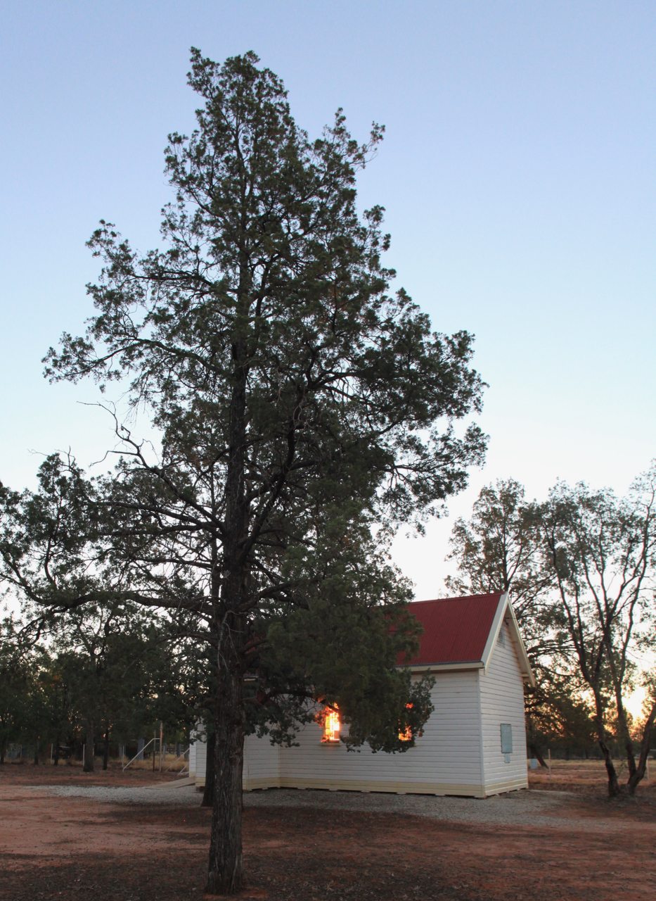
I was just in time to catch the sunset.

And I attempted a rinky dink ethereal shot of light glowing through the church windows. Not sure it worked.
While taking that shot I (almost) stumbled across a dreaded Hudson Pear cactus. Apparently quite nasty. One of the Cumborah ladies got a spine stuck in her forehead, and because it was barbed (spine, not head) it took a bit of getting out.

And of course I timed my arrival so I was able to attend the Cumborah Coffee Club the following morning (every Thursday, 10am) and this time was able to take along a “plate” - a cinnamon cake from Dirranbandi.

In the photo (but not in order) are Janet, Margaret, Rosemary, Joan, Lance, Joe, Lionel and Kay. Thanks again to everyone at Cumborah for making me feel welcome.
Then it was back on the road again by midday, first SE towards Walgett to meet the Kamilaroi highway, then west.

This was a long, straight road and I reached Brewarrina about mid afternoon, filled the tank and checked in to the caravan park.


I set up the van, did some washing, had a shower, assembled my dinner, and emerged to find that the owner had lit a fire before choofing off home.

Never mind. I got my music & speaker, grabbed a coldie (water) and settled down for a couple of hours while my stew stewed.

Very pleasant,
Next morning I woke to a cloudy sky, horizon to horizon. First since leaving Finley four weeks earlier. I grabbed a LARGE coffee from the bakery and headed west again to Bourke.
I topped up my supplies at the local IGA and went down to the river for a look-see.


Apparently this was the best Murray Cod fishing location in Australia.
Turned the corner and found ANOTHER one. This time in festive colours, as if for camouflage.

Across the road was the Port of Bourke, at one time the world’s largest inland port for exporting wool.

Opposite, there was a nice grassy park

Which was on top of the river bank

Nearby was an old wharf (picture from TripAdvisor)

The wharf was on several levels, presumably to cope with variations in the level of the Darling River, so I just had to go down the steps.

From the lower levels the views downstream (I think) …

… and upstream …

… and downstream again …

… and upstream again …

… were all pretty much the same so I started up the stairs again …

I had wanted to visit the Gundabooka National Park south west of Bourke, and intended to stay a night or two. So I visited the Information Centre and all was good until the very helpful lady mentioned the bull dust on the access road, half a metre deep in the (dry) creek bed. Ok, I thought, that will be ok if it doesn’t rain.
I set off again, this time heading south on the Kidman Way. After a few minutes the horizon looked like this. Rain in the distance.

(apologies for the poor photo)
And very soon after I took that photo I got spots of rain on the windscreen.
At the Gundabooka exit things didn’t look any more promising.

I didn't want to tempt fate and get bogged on the dirt access road so I continued south towards Cobar.

At Cobar I bought a life-giving flat white, drove past a slag heap …

And up a hill to what was advertised as a lookout on top of the Fort Bourke hill.
Sure was a lookout. Or rather a lookdown.

Monster hole in the ground being the entrance to a gold mine.

Large mining vehicles go through that entrance at the bottom.
Looking in the other direction the tracks and poles led to the horizon and presumably Nyngan.

Back on the road again and the dreary weather continued.

Common to nearly all parts of my journey were occasional large round groupings of white dots, the dots being fairly evenly spaced.

Turns out these are droppings left by birds feeding on the roadkill pizzas. Quite carefully composed - almost pointillist - and very consistent across NSW and QLD.
I kept driving until I reached a small village called Mount Hope. The village makes space available for trucks and caravans to rest and recharge in return for donations and eating at the pub. I left a donation but didn’t go to the pub.
Overnight the wind picked up and the rain started in earnest, getting quite heavy at some points. I had a shower and a watery instant coffee, then started driving before 7am.

I paused at Hillston around 8am for a wake-me-up creamy flat white. The young person making the coffee was really busy telling her life story to her boss, and could only do one task at a time. So she carefully heated the milk to what I presume was EXACTLY the right temperature (she spent a long time checking the temperature with a probe and carefully set it aside once she got the right reading). Then she ground some beans, compressed into the little espresso pancake and put that into the machine, then espressed the coffee, poured the coffee into a tall paper cup, and carefully added the milk.
While that was going on a couple of ladies came in with their daughters, on their way to, or from (I hope) ballet or guides, or rugby, or similar Saturday morning activity. The girls picked up the menus and started “can I have a milk shake please mum please please can I can I can I? Can I have a milk shake please mum?” repeated forever. I beat a hasty retreat with my coffee.
Back on the road with my super sized super-caffeine treat! Eyes wide open with glazed stare and mega-aware of Everything.
I was buzzing. At anything.
There wasn’t much traffic around so I couldn’t grind my teeth at drivers so instead I glared at the road which for a change was inoffensive and level and well behaved.
Fortunately my music came to the rescue.
Calming classical guitar.
Tranquil Three Tenors.
Whining Woody Guthrie
“I wish I had some shoooos
It is giving me the bloooos
My feet are getting sore
Ate my last shoes in some stoooos”
After a while the caffeine wore off and my brain returned to what passes for normal.
I was fairly close to my 4-weeks-previous northbound route (around 50km at this point near Goolgowi)

The rain kept persisting down. Not hard and torrential but light and soaking. I didn’t realise how persistently soaking it was until I got out of the way of a road train.
As I slowed down and moved on to the road shoulder (which appeared to be solid with a gravel surface) the tyres dug through the surface to a very slippery layer of red dirt. Because the shoulder was on a slope the caravan slid a bit downhill and pulled the back of the ute with it. Not a huge amount but noticeable, and I had to use 4WD to get back on the sealed road surface.

This is why I moved off the road. Leave plenty of space for the big truck. Much easier for everyone.

Much much later, west of Hay, the rain slowed and the clouds started to break up.
Looking east the weather was grey and wet

But the road ahead looked ok.

I kept driving and considered stopping at Hay, but the streets were full of people waving and excited. For a moment I thought my 15 seconds of fame had arrived but then noticed that there were some events. First was a five day bowls competition, but I had difficulty with the notion of people crowding the footpath in their eagerness to see geriatric Bowls competitors hobble down the high street.

But no. There was an event for Mini (car) enthusiasts, and they were about to parade down the main drag. In addition there was a Bachelor & Spinster Ball that weekend, so the utes were parading with the Minis.
These photos from their respective web sites


So Hay was out of the question and I drove on to Deniliquin by which time it had started raining again.
There was now quite a lot of traffic. Mainly pimply youths driving utes to the Hay B&S Ball.
What’s the collective noun for a group of pimply youths? Flock of sheep. Herd of cattle. Pimpernuckle of youths? A pussel of youths?
I drove on again to Echuca, which was also grey and miserable. I drove on again, got lost (!) in Elmore (there is only one corner in Elmore and I missed it!) and finally reached Kilmore at 5pm the same day I left Mount Hope.
A bit of a disappointing and anticlimactic end to this little trip, brought on by rain.

KEY STATISTICS (because I can)
Distance travelled: 5,600 km
Diesel used: 670 litres
Economy: 12 litres / 100km
Diesel average price: 152.5 cents/litre
Diesel lowest price: 138.9 cents/litre at Coonamble
Diesel highest price: 158.9 cents/litre at Narrabri
Total cost of diesel: $1,020
Cost of diesel each day (38 days): $28
Cost of diesel each day (38 days): $28
Accommodation cost: $500
Total nights: 37
Nights in caravan parks: 13
Nights in free / cheap camps: 24
Average cost: $13.50
Meals in pubs or cafés: 5
Steve Special meals: 32
Approx cost of groceries: $320
Cost per Steve special meal for one: $10 (probably inflated by non-food groceries)
Approx cost of mixed nuts: $200 (about 6 kilos)
Total spend: $3020
Incidentals (coffees, shows, beers): approx $400 excluding one-off purchases.
Mountains climbed: 1 (the lookdown at Cobar)
Streams forded: 0
Rainbows followed: 0
Dreams found: 0 (but working on it)
============
A favour please.
For those of you who managed to read this far, could you please let me know which aspects of the blog posts you enjoyed (or not):
The pictures?
The Ag Shows?
The plain narratives?
The "Steve's brain losing touch with reality" narratives?
Other?
I would appreciate some feedback ... thanks!