Wednesday 3 July 2019

34 - There and back again - Jugiong - Batemans Bay - Jugiong

Couldn't resist the Bilbo Baggins reference in the title.

Last time I left you - fellow travellers in life - I had made a revictualling trip (or as my old mate Jed would have expressed it "a vittlin trip") from Jugiong to Cootamundra and back, and was settling down to a warm and peaceful evening.


I stayed there another day then on the Monday (first Monday in June) I set off for the coast with no specific plans ... perhaps stop overnight at Bungendore Showgrounds or thereabouts before driving on to the coast to catch up with Diana and Alan.

It was a fairly uneventful drive up the freeway to Yass, where I re-dieseled and acquired a very large therapeutic flat white before continuing down the Barton Highway towards Canberra. Even the Barton was relatively civilised for that time of day. On the map it is marked red - perhaps from reputation as a bit of a traffic snarl through Canberra's northern outposts - but for me it worked just fine.

There and back again - click to enlarge

So I bounced off Canberra and moseyed up the Federal Highway a few km before turning right on to Bungendore Road, and discovering once again the difference between Highways and secondary roads. Not that it was undriveable, just unexpectedly undulating and bumpy, which gave the already-consumed bucket of flat white a bit of a scare.

Bungendore Road improved and wended its way up a hilly bit before a steep descent ("Trucks and Buses use low gear" stuff) to the next valley. I had just recovered from the Steep Descent trauma when I noticed a small "RV camp" sign on the right. Naaah, I thought, can't be Bungendore Showgrounds, too soon. But after another couple of bends I found myself in the mighty metropolis itself so stopped to consult the wiki and sure enough it was. Being male and a bit focused on getting somewhere ahead of myself I decided not to turn around and trek backwards a couple of km to the showgrounds. I didn't pause for long in Bungendore as I didn't need any more coffee, for indeed the bucketful I had slurped through since Yass was letting me know it was still there and did NOT like bumpy roads, THANKS! 

I continued my trek along the Kings Highway, the B52, but I didn't see any love shacks. Or rock lobsters. Perhaps the rock lobsters are nocturnal. Crunch crunch. But I didn't notice any crunchy roadkill either, so I don't know where they hide.

Anyway a very nice drive. Picturesque and relaxing. Not much traffic heading to the coast on this Monday. Called in to the Warri Camping Reserve near the bridge over the Shoalhaven River. Quite spacious and with a long-drop, and would make a very nice overnighter, but the wind was picking up and some very dark and frowning clouds were lurking and there weren't really many spots that were both level and away from trees. So I made an executive decision, a captain's call, a pilot's prerogative, and called ahead to a caravan park in Bateman's Bay to book a site for a couple of nights.

Well. If I thought the descent to Bungendore was a bit of a thrill I certainly wasn't well prepared for the drive down Clyde Mountain from Braidwood to Batemans Bay. I was doing some figurin' the other day and concluded that I have a grand total of around 300 hours towing experience, so even with a lightweight caravan (driving 4 tonnes of ute & van) I wasn't too confident driving down this twisty turny steep road with very few places to let faster traffic pass. Only five km but it managed to raise a sweat (or was that caused by turning the heater up to 11?). Seems like a lovely bit of countryside. Wish I was able to look at it.

So I got my breath back and ambled into Batemans Bay (north), then over the bridge to Batemans Bay (CBD), turned left, and followed Beach Road past Corrigans Beach to Caseys Beach where I found my excellent little caravan park and parked the van, grabbed some food at the IGA back at Corrigans Beach, and settled down for the evening. 

Just as well I sought shelter in a caravan park! No sooner had I set up than the wind picked up, the rain started going sideways, and the clouds started groaning. This was the coastal storm that moved up the NSW coast and hit Sydney a couple of days later during the first week of June. Not as big as the Great Storm of '87 or the Big Wind of '54, and not icy like the Big Freeze of '63, but windy and blustery all the same. As usual I hadn't lowered the caravan legs so I was rocked to sleep by the wind.

I would like to report that I woke the next day to bright and sunny skies, but this is not the Famous Five and that didn't happen. Instead it was leaden grey (gray for the septics reading this) and gusty. I grabbed the cameras and wandered across the road to the beach.

This lonely little rainbow lorikeet perched itself on a fence, the wind lifting feathers on its back. Looked terribly cold and miserable but could well have been smiling inside - who am I to say? 

A miserable-loooking specimen
The sea had a dull green stormy look to match the clouds, which by then were showing signs of parting to let through some sunshine.

The lonely sea and the sky. Vest and socks not dry.
A mere five minutes later the clouds had closed over again and the wind picked up.


The sun did come out for a millisecond or two. This is looking west across Corrigans Beach towards Batemans Bay (town).


The sky continued to darken and look angry again.


The fresh smell of newly beached seaweed brought back childhood memories of the rock pools around Houghton Bay and Waitaha Cove. Exhilarating, and evoked a sudden need for a bento box. But no sushi trains in sight, so I settled for a fork-full of tinned tuna on a SAO cracker. Sorry, I exaggerate. It was a Ritz cracker. Smaller than SAO. And round not square.

After that sumptuous lunch the clouds were still there. As were the sea and the sand, and seaweed. And that wonderful smell.


That was enough excitement for one day, so I bought some more groceries from the IGA and sorted some photos and wrote up the blog (post 33), again rocked to sleep by a slightly gentler stormy wind.

Next day there were some definite signs of blue sky and sunshine.


So I put on my striding strides and strode the 200 meters to the next little cove at Sunshine Bay, and exhausted by that marathon trek I sat down to catch my breath before walking around to the rock pools.


Interesting rocks - dark stone with creamy yellow stripes.


Back at the other end of the cove the seaweed was piled quite deep.


And the sea kept trying to get my boots wet.


In places the clouds were mimicking the seaweed pattern.


There were some impressive waves crashing over rocks. I'm not sure I captured it well. You probably had to be there.


I headed back the other way to the much larger and spacious Corrigans Beach.


Not as much seaweed piled up, but the wave patterns in the sand were quite nice.


There were many seagulls wandering around the beach and even doing little dances on the wet sand.


So that was a pleasant outing.

The next day I hitched up, drove north on the very pleasant Princes Highway for a very pleasant couple of hours with Diana and Alan (along with some delicious cake!) and got lost on the Princes Highway in Nowra before refuelling in Bomaderry and turning south again to find Turpentine Road / Braidwood Road which took me over the hills and to the west. A great drive, very little traffic, scenic, and generally good road surfaces (apart from that dip coming south out of Nerriga - acne on the road evidence that some drivers of heavy vehicles get taken by surprise).

Onwards to Goulburn, where I stayed in a motel and had a meal cooked for me. Luxury compared with my usual caravan cooking. The hardships we go through. Tell young people these days and they won't believe ya.

The following day - Friday 7 June - WAS sunny, so I refuelled and set off on a quest to find the source of the Lachlan River. I moseyed down the freeway to Breadalbane, which is on the old (pre-freeway) Hume Highway. I crossed the railway and followed the directions on Google Maps and Bing Maps and Apple Maps until I found myself at their consensus source of the Lachlan. Which was in this paddock somewhere around the eighth clump of grass from the top, in the middle.


Well that didn't float my boat in the river, as it were, so I turned around to walk back to the ute and on the other side of the road spied some reedy marshy goodness that I decided arbitrarily was the source of the Lachlan.


Instead of going back to the freeway or the old Hume I turned right on to Mutmutbilly Road and soon came in sight of thirty or forty hulking giants rising from the plain.


However I was too preoccupied and instead drove on to St Brigids church and graveyard.


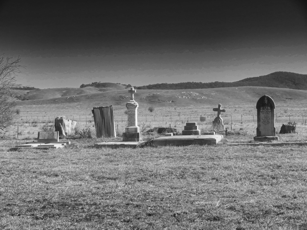
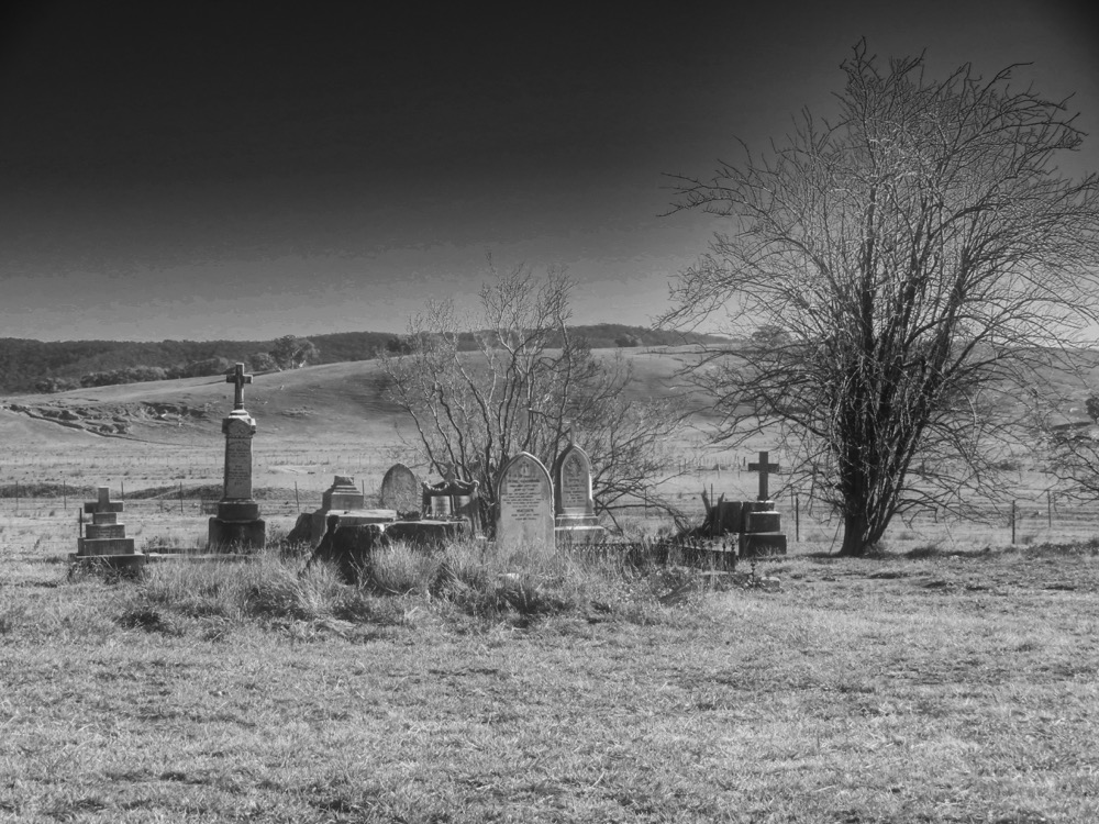
Moderately spooky scene duly recorded I continued towards Cullerin. On the right was the nascent river protected by phalanxes of guard sheep.

Guard sheep. Click to enlarge and see the fire in their eyes.
I turned around and noticed the hulking giants had come closer, some with arms well nigh two leagues in length. Lucky for them I had left my armour and knightly weapons behind, or I might have removed the foul brood from the face of the earth..


I remounted Rocinante the ute and rode drove on, following the old Hume (ah - them were the days - single lane each way - 100kph down the busy narrow highway on dark and stormy nights) to Gunning, where I checked out Barbour Park for some future visit. The "Beware of the snakes" sign set the tone. Very nice, and close to shops, pub etc but perhaps a little busier than I like.


So I turned right on to Warrataw Street, which turned into Dalton Road and a few minutes later - surprise - I arrived at Dalton. The locals were hanging out at the pub.


I turned right on to Bevendale Road, seeking to catch up with the Lachlan which had snuck away from the main road while I was enjoying the Gunning and Dalton sceneries. I caught up with the river a few km later, at which point (I assume) it had turned into a permanent waterway.


At this point I surrendered to a nagging doubt, checked my odometer and discovered I was getting close-ish to a dealer service. Another captain's call, and I decided to head south again, instead of continuing to follow the Lachlan.

I could have booked into a dealer in NSW but I wanted to get a couple of upgrades as well, so I took the next left down Blakney Creek North Road and drove back through Yass and grabbed a drink at Bookham and eventually stopped at the showgrounds at Jugiong, which I had left on Monday 3 June.

Another donation and a great night's sleep and I was up with the sparrows to head south. As I drove out of the mist and up the hill to join the freeway south I noticed the fog in the Murrumbidgee River valley. There is a great rest area at the top of the hill - an old truck stop? It looks over the valley and on this morning there was a great view of the mist and curly clouds.


So I continued south, stopped at Holbrook to refuel and check out the submarine (I hadn't stopped there for at least 30 years). The gent in red saw my camera and hoofed it. Rapido. Perhaps he was a republican spy sneaking a look at our advanced defence technologies. Or not.


So finally the run south. Paused to have a chat and café olé with Benalla Bob (thanks Bob! Great to catch up as always) then another couple of hours to Kilmore for maintenance and upgrades.

Sunday 2 June 2019

33 The Rock - Wagga - Gundagai - Jugiong - Cootamundra

Good morning fellow travellers! Travellers on the road or travellers in life!

What a great morning it is - cloudless, sunny, morning fog just gone. Morning migration of caravans and motorhomes well underway. Many dribbling waste water as they leave. Tut!

Ah well, back to the business at hand. At the end of Episode 32 I was trying to figure out how to take an interesting photo of a cloudless sunset on a flat plain, and in my ignorance getting nowhere (any ideas, let me know!).

The next morning I packed up and trundled east along the Sturt Highway. I had a look at the Birdcage Reserve Rest Area as a possible camp, but couldn't see any "perfect" sites close to the river that were not under trees (not wanting falling limbs, wanting sun-on-the-panels, and all that) so I moved on. Probably a mistake. Lovely area.

So I moseyed along. Had a squiz at Darlington Point and that wasn't "perfect" either so I kept going. Probably another mistake. Same story at Narrandera.

Stopped at Collingullie for a cold drink, temperature being way up there in the high teens. And saw a road sign to The Rock. Hah! I thought. I have driven through The Rock a couple of times on The Olympic Way, and stopped there several times in the Sydney-Melbourne train either just after lunch or stupid o'clock in the very early morning. But never got out for a look.

Quick check on the trusty app, quick u-ee, and down Rock Road, which turned into Collingullie Road the closer it got to The Rock. Makes sense.

So The Rock community have installed some very good facilities at their rec ground - newish showers and toilets with plenty of hot water, all for a donation. With a dump point and plenty of space for caravans and motorhomes.

Installed myself, popped and propped the top (the extra solar panel means the popped top unpops unless propped), set up the 12v TV (upon which I view Mr Attenborough whose gentle tones usually make me drift off), turned on the gas and fridge, and wandered off down the road for a look at The Rock.


Shame about the wires on the left, and the lens smudge. I was walking and couldn't walk far enough to get a wireless photo, so I walked back towards The Rock CBD in the hope of spotting the train (no, I wasn't wearing an anorak at the time!) south, then the train north. Or was it the other way around? They pass somewhere just north of Cootamundra. I think - correct me if I'm wrong. But I was too late to see the trains, having walked too far in the opposite direction trying to get a photo of The Rock without wires doing a photo bomb.

Anyway, it seems that The Rock itself (not the town) was originally called The Hanging Rock, by virtue of a bit of rock that was hanging on to the side of the sticking up bit. But that hanging bit let go in 1874 so the locals in turn had to let go of that bit of the name.

The town is small and spacious, tidy, with several solid, well-kept buildings from the legendary past. This is an old branch of the CBC.


Even an important part that fell off a plane, perhaps from the nearby Wagga base.


By pure luck it fell so that its connecting bit pronged the concrete and the edge came to rest parallel to the ground. Very clever and little wonder the locals added notations to its surface.

Noice little group of shops. A butcher, café and some others.

Got pretty busy at the Rec Reserve on the Thursday night with football and netball practice. Good to see and hear all the energy being expended.

I was determined to get a photo of The Rock sans câbles so I choofed off down The Olympic Way (showing my age there - it seems that The Olympic Way was renamed Olympic Highway, way back in 1996 but according to Wikipedia is not considered a highway by NSW RMS or whatever it is called this year ... but I like The Olympic Way). Anyway I wandered down The Olympic Way (there!) and turned right - west - at Yerong Creek then right again - north - and onto Vincents Road so I could sneak up on the back of The Rock. It worked! Caught them napping and there was an absence of wires.

As a bonus I noticed that there was a mini-me-The-Rock just south of The Rock. This photo from the south west. The Rock on the left. Mini-me-The-Rock on the right.


Then another couple of The Rock from its west, without the young upstart. And without wires.


That was enough Rocking, so I drove back to The Rock (metro), turned left - north - on Collingullie Road, which at some point turned into Rock Road, and found myself back in Collingullie. Now, the Crossroads Hotel, aka the Gullie Pub, has a flattened and manicured and well-prepped area out the back purposely set up for RVs. No powered sites, but water and a short meander to and from the pub. So I had a couple of beers (first since Edenhope in the Wimmera) and grabbed a meal - they stick full counter meals in boxes to take away - and took it back to the van. Being Saturday, the netball and football clubs were celebrating after their games - I think one lost and one won but it didn't appear to matter, they were celebrating - and there was a 21st party in the covered beer garden. That went on for a while. Again it was great to hear young people having a good time. The noise faded well before the pumpkin hour which I thought was very reasonable for a Saturday.

It had been overcast and raining since I left Hay and I felt I needed to charge the batteries (not sure I actually needed to but it gave me an excuse) so the next day I tootled off to Wagga Wagga and set up in a caravan park very close to the airport and RAAF base. At the gate of the RAAF base there is a Heritage Centre with some large model aircraft outside (did I detect traces of glue and stick-on decals?).

A Gloster Meteor.


An English Electric Canberra


A General Dynamics F-111C. I wonder if this was the one that dropped the wing thing at The Rock.


GAF Mirage IIIO


And a Macchi MB-326H trainer (which I think must have replaced a Sabre at the gate - anyone?)


Inside there were some great exhibits including a ration pack, which should be a sight for hungry eyes - John? Bob?


And a Beaufighter cockpit.


So having immersed myself in RAAF Wagga history, and restocked the pantry, and recharged the batteries, I left the green and pleasant city of Wagga, crossed the Murrumbidgee and followed Oura Road along the north bank of the river through some green and pleasant land.


At Wantabadgery I turned right onto River Road and then into the Sandy Beach Reserve. Excellent camping spot with plenty of space and ageing but very clean long drops.


The river was full of flood debris. No idea how old it all was, but I was very impressed by the water power required to move it all.


Sandy Beach was nice, but the weather wasn't. This was the first day of the alpine blizzards at the end of June, and Sandy Beach was cold and damp. Very cold and damp. So after one night I moved on again to Gundagai and took refuge in a motel, because I can.

Hid away there for a day before I emerged and went next door to the supermarket for vittles (victuals for the pedantic - pronounced vittles by the Clampetts). Very nice motel, by the way. The Gabriel (no I don't get a kickback - I just thought it was a very good very basic motel). Without a breakfast cupboard but with a shub, which sort of dates its construction. The current owners have the units feeling fresh and new and comfortable.

A bit like Gundagai, one of my favourites.


The old court house, and the old gaol in the dark building up the road on the left.
 

The main drag in Gundagai. Looking west towards the Hume Highway.


And of course what visit to Gundagai would be complete without a visit to the Niagara?


Plates reminiscent of the old NZR crockery.


Stop at Palmy, race to the refreshment counter, grab the pie-in-a-paper-bag-on-a-chunky-plate and the tea-in-chunky-cup-and-saucer. Juggle on the lap. Get pastry crumbs everywhere. Stick the used crockery under the seat. Collected in Woodville. Do it again at Waipukarau.

Anyway for those who are not familiar with The Niagara Café, it was opened in 1902, and refurbished in 1938. Most of what you see in these pictures - the shiny counter, signage, mirror behind the counter, wood-lined booths - date from that refurbishment.


Note the tiny Parthenon above each mirror. At one point apparently there was a juke-box selector at each table so perhaps the mirrors are filling the spaces vacated by those. Anyone?


So after an enjoyable couple of days luxuriating in Gundagai-motel, it was time to move on. On the way out I spied a sign pointing to a lookout, so hauled the van up steep and narrow Hanley Street to a rewarding view back over Gundagai.


This is the view from the top of that hill looking north-west towards the Hume.


And so back on the road again, at least for a couple of miles (4.5 according to Wikipedia, which tells no lies ...) to the Dog on the Tuckerbox.


Plenty of travellers about.


Then north again to Jugiong, which has a magnificent large showground that offers camping and toilet amenities funded by donations.


I took a walk down to the very nice river


Found some exotic looking deciduous.


Golden ash?


Anyway they looked nice.


Then back up to the main drag in Jugiong - the Old Hume Highway.


Memorial to Sergeant Parry, shot by a bushranger in 1864 - even before I was born!


There is a pub and a couple of nice tourist traps in Jugiong, but no groceries, so on a very clear sunny Saturday I saddled up and headed west (as one does) to Cootamundra. What a great drive up Rose Hill Road through some stunning scenery. The photos don't do it justice.


Cootamundra is another spacious green and pleasant town so after I re-vittled I went for a walk down the main drag.


Had a very nice coffee at "Helen's Coffee Lounge" along with a decadent and naughty (for me) muffin, then said goodbye to this green and pleasant - and sunny - town and headed back to Jugiong to get some more of that great showgrounds ambience and space and write up this blog.

Chez Moi - wings drying in the afternoon sun.
Now, as the day draws on again it is nearly that orangey evening time so I must get a coffee and get this published.