What a great morning it is - cloudless, sunny, morning fog just gone. Morning migration of caravans and motorhomes well underway. Many dribbling waste water as they leave. Tut!
Ah well, back to the business at hand. At the end of Episode 32 I was trying to figure out how to take an interesting photo of a cloudless sunset on a flat plain, and in my ignorance getting nowhere (any ideas, let me know!).
The next morning I packed up and trundled east along the Sturt Highway. I had a look at the Birdcage Reserve Rest Area as a possible camp, but couldn't see any "perfect" sites close to the river that were not under trees (not wanting falling limbs, wanting sun-on-the-panels, and all that) so I moved on. Probably a mistake. Lovely area.
So I moseyed along. Had a squiz at Darlington Point and that wasn't "perfect" either so I kept going. Probably another mistake. Same story at Narrandera.
Stopped at Collingullie for a cold drink, temperature being way up there in the high teens. And saw a road sign to The Rock. Hah! I thought. I have driven through The Rock a couple of times on The Olympic Way, and stopped there several times in the Sydney-Melbourne train either just after lunch or stupid o'clock in the very early morning. But never got out for a look.
Quick check on the trusty app, quick u-ee, and down Rock Road, which turned into Collingullie Road the closer it got to The Rock. Makes sense.
So The Rock community have installed some very good facilities at their rec ground - newish showers and toilets with plenty of hot water, all for a donation. With a dump point and plenty of space for caravans and motorhomes.
Installed myself, popped and propped the top (the extra solar panel means the popped top unpops unless propped), set up the 12v TV (upon which I view Mr Attenborough whose gentle tones usually make me drift off), turned on the gas and fridge, and wandered off down the road for a look at The Rock.
Shame about the wires on the left, and the lens smudge. I was walking and couldn't walk far enough to get a wireless photo, so I walked back towards The Rock CBD in the hope of spotting the train (no, I wasn't wearing an anorak at the time!) south, then the train north. Or was it the other way around? They pass somewhere just north of Cootamundra. I think - correct me if I'm wrong. But I was too late to see the trains, having walked too far in the opposite direction trying to get a photo of The Rock without wires doing a photo bomb.
Anyway, it seems that The Rock itself (not the town) was originally called The Hanging Rock, by virtue of a bit of rock that was hanging on to the side of the sticking up bit. But that hanging bit let go in 1874 so the locals in turn had to let go of that bit of the name.
The town is small and spacious, tidy, with several solid, well-kept buildings from the legendary past. This is an old branch of the CBC.
Even an important part that fell off a plane, perhaps from the nearby Wagga base.
By pure luck it fell so that its connecting bit pronged the concrete and the edge came to rest parallel to the ground. Very clever and little wonder the locals added notations to its surface.
Noice little group of shops. A butcher, café and some others.
Got pretty busy at the Rec Reserve on the Thursday night with football and netball practice. Good to see and hear all the energy being expended.
I was determined to get a photo of The Rock sans câbles so I choofed off down The Olympic Way (showing my age there - it seems that The Olympic Way was renamed Olympic Highway, way back in 1996 but according to Wikipedia is not considered a highway by NSW RMS or whatever it is called this year ... but I like The Olympic Way). Anyway I wandered down The Olympic Way (there!) and turned right - west - at Yerong Creek then right again - north - and onto Vincents Road so I could sneak up on the back of The Rock. It worked! Caught them napping and there was an absence of wires.
As a bonus I noticed that there was a mini-me-The-Rock just south of The Rock. This photo from the south west. The Rock on the left. Mini-me-The-Rock on the right.
Then another couple of The Rock from its west, without the young upstart. And without wires.
That was enough Rocking, so I drove back to The Rock (metro), turned left - north - on Collingullie Road, which at some point turned into Rock Road, and found myself back in Collingullie. Now, the Crossroads Hotel, aka the Gullie Pub, has a flattened and manicured and well-prepped area out the back purposely set up for RVs. No powered sites, but water and a short meander to and from the pub. So I had a couple of beers (first since Edenhope in the Wimmera) and grabbed a meal - they stick full counter meals in boxes to take away - and took it back to the van. Being Saturday, the netball and football clubs were celebrating after their games - I think one lost and one won but it didn't appear to matter, they were celebrating - and there was a 21st party in the covered beer garden. That went on for a while. Again it was great to hear young people having a good time. The noise faded well before the pumpkin hour which I thought was very reasonable for a Saturday.
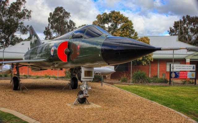
It had been overcast and raining since I left Hay and I felt I needed to charge the batteries (not sure I actually needed to but it gave me an excuse) so the next day I tootled off to Wagga Wagga and set up in a caravan park very close to the airport and RAAF base. At the gate of the RAAF base there is a Heritage Centre with some large model aircraft outside (did I detect traces of glue and stick-on decals?).
A Gloster Meteor.
An English Electric Canberra
A General Dynamics F-111C. I wonder if this was the one that dropped the wing thing at The Rock.
GAF Mirage IIIO
And a Macchi MB-326H trainer (which I think must have replaced a Sabre at the gate - anyone?)
Inside there were some great exhibits including a ration pack, which should be a sight for hungry eyes - John? Bob?
And a Beaufighter cockpit.
So having immersed myself in RAAF Wagga history, and restocked the pantry, and recharged the batteries, I left the green and pleasant city of Wagga, crossed the Murrumbidgee and followed Oura Road along the north bank of the river through some green and pleasant land.
At Wantabadgery I turned right onto River Road and then into the Sandy Beach Reserve. Excellent camping spot with plenty of space and ageing but very clean long drops.
The river was full of flood debris. No idea how old it all was, but I was very impressed by the water power required to move it all.
Sandy Beach was nice, but the weather wasn't. This was the first day of the alpine blizzards at the end of June, and Sandy Beach was cold and damp. Very cold and damp. So after one night I moved on again to Gundagai and took refuge in a motel, because I can.
Hid away there for a day before I emerged and went next door to the supermarket for vittles (victuals for the pedantic - pronounced vittles by the Clampetts). Very nice motel, by the way. The Gabriel (no I don't get a kickback - I just thought it was a very good very basic motel). Without a breakfast cupboard but with a shub, which sort of dates its construction. The current owners have the units feeling fresh and new and comfortable.
A bit like Gundagai, one of my favourites.
The old court house, and the old gaol in the dark building up the road on the left.
The main drag in Gundagai. Looking west towards the Hume Highway.
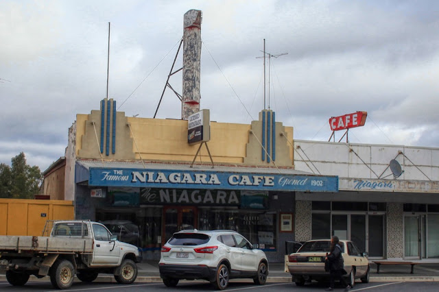
And of course what visit to Gundagai would be complete without a visit to the Niagara?
Plates reminiscent of the old NZR crockery.
Stop at Palmy, race to the refreshment counter, grab the pie-in-a-paper-bag-on-a-chunky-plate and the tea-in-chunky-cup-and-saucer. Juggle on the lap. Get pastry crumbs everywhere. Stick the used crockery under the seat. Collected in Woodville. Do it again at Waipukarau.
Anyway for those who are not familiar with The Niagara Café, it was opened in 1902, and refurbished in 1938. Most of what you see in these pictures - the shiny counter, signage, mirror behind the counter, wood-lined booths - date from that refurbishment.
Note the tiny Parthenon above each mirror. At one point apparently there was a juke-box selector at each table so perhaps the mirrors are filling the spaces vacated by those. Anyone?
So after an enjoyable couple of days luxuriating in Gundagai-motel, it was time to move on. On the way out I spied a sign pointing to a lookout, so hauled the van up steep and narrow Hanley Street to a rewarding view back over Gundagai.
This is the view from the top of that hill looking north-west towards the Hume.
And so back on the road again, at least for a couple of miles (4.5 according to Wikipedia, which tells no lies ...) to the Dog on the Tuckerbox.
Plenty of travellers about.
Then north again to Jugiong, which has a magnificent large showground that offers camping and toilet amenities funded by donations.
I took a walk down to the very nice river
Found some exotic looking deciduous.
Golden ash?
Anyway they looked nice.
Then back up to the main drag in Jugiong - the Old Hume Highway.
Memorial to Sergeant Parry, shot by a bushranger in 1864 - even before I was born!
There is a pub and a couple of nice tourist traps in Jugiong, but no groceries, so on a very clear sunny Saturday I saddled up and headed west (as one does) to Cootamundra. What a great drive up Rose Hill Road through some stunning scenery. The photos don't do it justice.
Cootamundra is another spacious green and pleasant town so after I re-vittled I went for a walk down the main drag.
Had a very nice coffee at "Helen's Coffee Lounge" along with a decadent and naughty (for me) muffin, then said goodbye to this green and pleasant - and sunny - town and headed back to Jugiong to get some more of that great showgrounds ambience and space and write up this blog.
 |
| Chez Moi - wings drying in the afternoon sun. |


